
Fusing Aerial and Mobile LiDAR Data for Efficient Mapping Projects
Discover how Caltech Group revolutionizes large-scale mapping projects by combining aerial and mobile LiDAR data.
With budget and time constraints, companies often struggle to perform high-resolution mapping projects using traditional surveying methods. However, Caltech Group has emerged as Western Canada's leading provider of geomatics services, offering an innovative solution. By fusing aerial and mobile LiDAR data, Caltech is able to provide efficient and accurate mapping for various industries.
Caltech's team brings together a diverse group of experts including surveyors, engineers, CAD specialists, technologists, and GIS professionals. Their extensive experience and expertise have made them the go-to company for geomatics services over the last three decades.
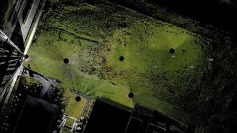
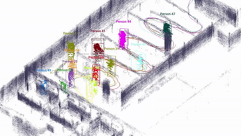
By combining aerial and mobile LiDAR data, Caltech is able to capture detailed and precise information about the Earth's surface. Aerial LiDAR involves using lasers mounted on aircraft to collect data from above, while mobile LiDAR utilizes similar technology mounted on vehicles to gather data at ground level. The fusion of these two data sets enables a comprehensive and complete representation of the terrain, ensuring accuracy and efficiency.
The primary findings of Caltech's approach have been remarkable. The fusion of aerial and mobile LiDAR data significantly reduces the time and cost involved in mapping projects. It allows for faster data collection, eliminates the need for extensive fieldwork, and provides highly accurate results. This technology has found applications in various industries, including infrastructure development, environmental monitoring, and urban planning.
The practical applications of Caltech's findings are immense. For example, in infrastructure development, accurate mapping plays a crucial role in planning and design. By combining aerial and mobile LiDAR data, engineers and planners can obtain detailed information about the terrain, landscape features, and existing infrastructure, helping them make informed decisions.
Beyond its immediate applications, the fusion of aerial and mobile LiDAR data has broader implications for the industry and society as a whole. It represents a significant advancement in geomatics technology, enabling faster and more efficient mapping projects. As technology continues to evolve, the potential for further advancements in LiDAR data fusion is immense.
In conclusion, Caltech Group's fusion of aerial and mobile LiDAR data offers a groundbreaking solution for large-scale mapping projects. The technology has proven to be both efficient and cost-effective, making it an invaluable tool for industries that require accurate and detailed mapping. As the industry continues to evolve, it will be fascinating to see how this technology further revolutionizes the field of geomatics.
LiDAR INSIGHTER Newsletter
Join the newsletter to receive the latest updates in your inbox.
