
LiDAR Solutions for airport challenges
Airports are increasingly using LiDAR-based software solutions to tackle their biggest challenges, leveraging the unique value of Spatial Intelligence.
"The demand for both passenger and cargo air travel has risen in a much less gradual way than we anticipated." - Thomas Romig, Vice President of safety, security, and operations at Airports Council International (ACI)
Anyone who often travels will be all too acquainted with the increasing problems that airports, airlines, and travelers are facing.
Airline delays and cancellations, longer TSA lineups, and lost bags, airports continue to struggle with personnel issues, such as a lack of baggage handlers, which has led to an increase in misplaced luggage.
Consumer complaints about airlines are up 300% as a result of all these problems.
In response, airport operators are implementing new technology to streamline processes and enhance the visitor experience.
This paper investigates how and why, by utilizing the special benefits of Spatial Intelligence, they are increasingly embracing LiDAR-based software solutions to meet these difficulties.
Why LiDAR?
Thanks to the Self-Driving Car application, which will be extensively deployed at scale sooner or (most likely) later, many individuals first learnt about the significance of LiDAR data.
That is what its name, Light Detection And Ranging (LiDAR), actually means.
Another significant non-technical benefit of this novel sensor is that no personally identifiable data is ever recorded.
The fact that this technology can watch moving objects and measure enormous quantities in an efficient and safe manner, a feature that is necessary and/or valuable in many applications, has recently gained a lot of interest, which is not surprising.
Such a beneficial technology has a sizable market; in fact, several billion dollars have been spent on the development of LiDAR hardware technology, and about 100 companies produce various types of LiDARs.
Why now?
LiDAR has become a useful option for airports as a direct result of the intense rivalry and abundant resources invested in hardware development.
Low costs and exceptional performance
In a short period of time, performance has significantly increased and cost has sharply fallen, making LiDAR competitive with older 2D sensing technologies across the majority of application categories.
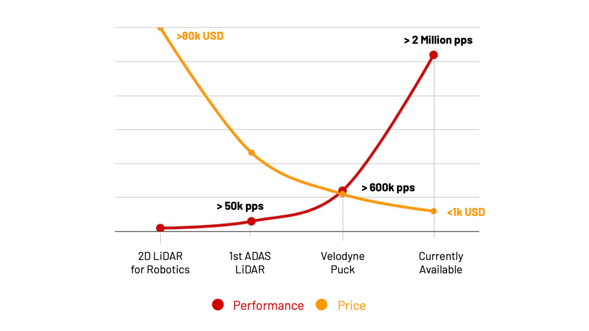
When one takes into account the overall number of units, installation, and processing expenses that are necessary to monitor a specified region, this is particularly pertinent for airports.
Suitable for a variety of settings
Airport buildings, terminals, parking lots, and the tarmac are all quite diverse places when it comes to choosing the best hardware: Long-range detection may be necessary in some situations, such as perimeter protection, whereas short-range, 360-degree coverage is significantly more important in other situations (i.e., Check-in zones and baggage claim).
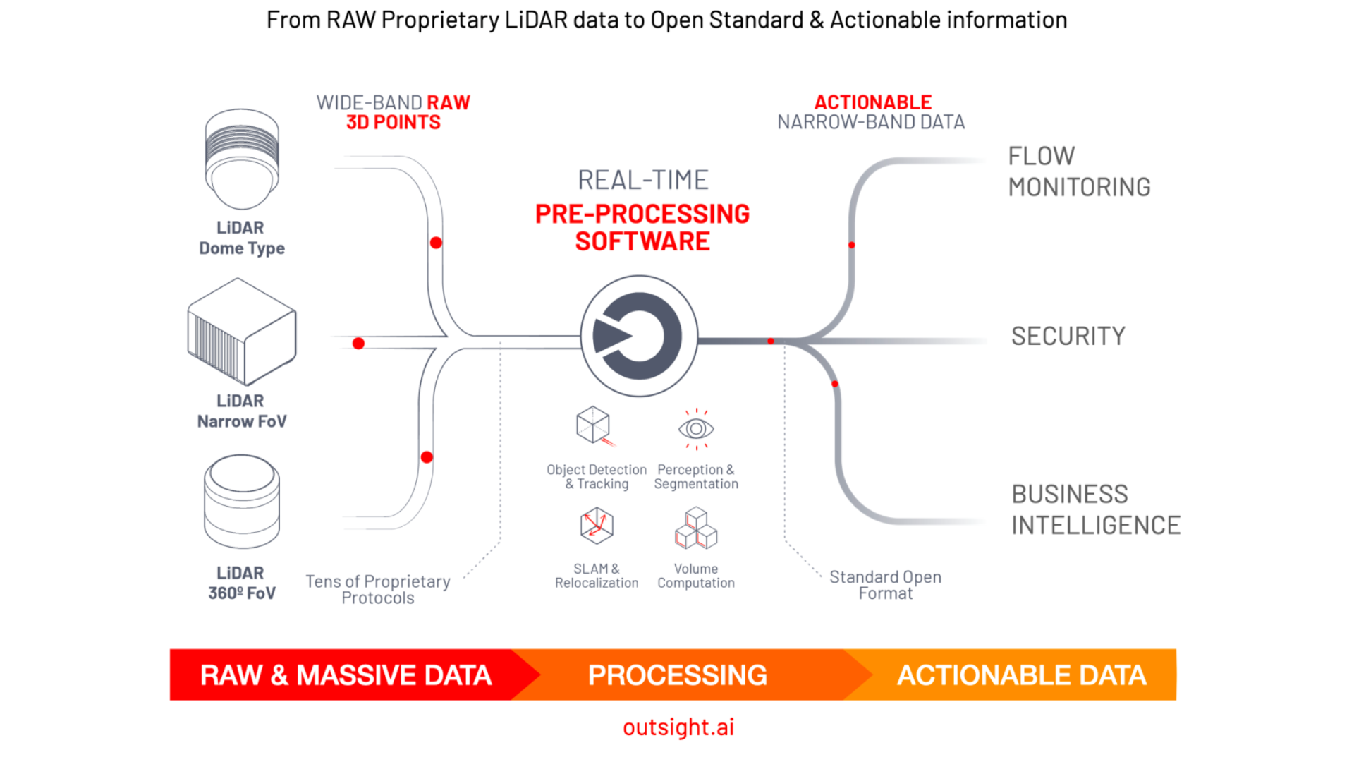
Quick and easy conversion into actionable insights
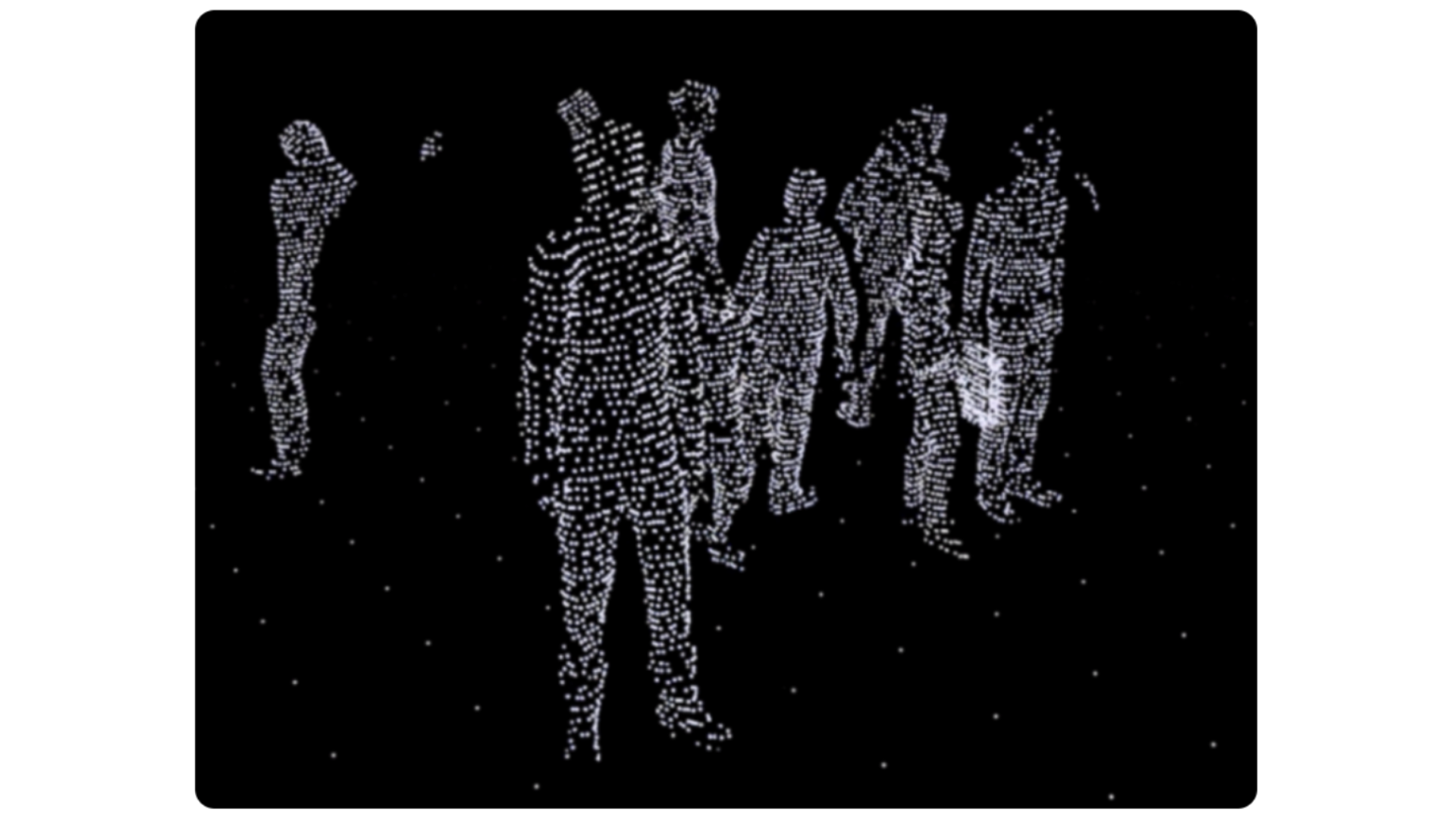
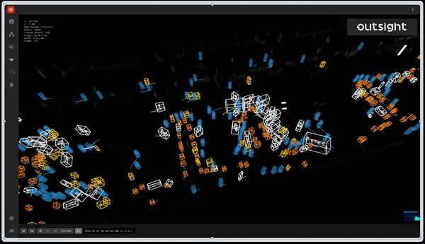
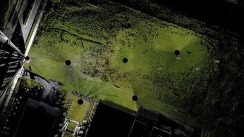
Without the proper software, LiDAR gear merely offers raw data that cannot be used "as is." What a luggage claim area looks like when utilizing LiDAR raw data that has not been processed is shown in the image below:
Humans see movement because of the way their brains interpret images, along with 95% of other LiDAR points that are just irrelevant.
Airports require a processing brain akin to this to actually utilise LiDAR data.
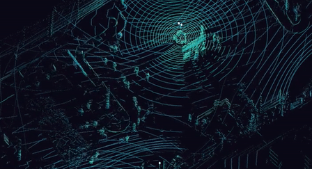
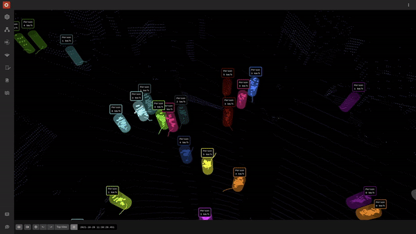
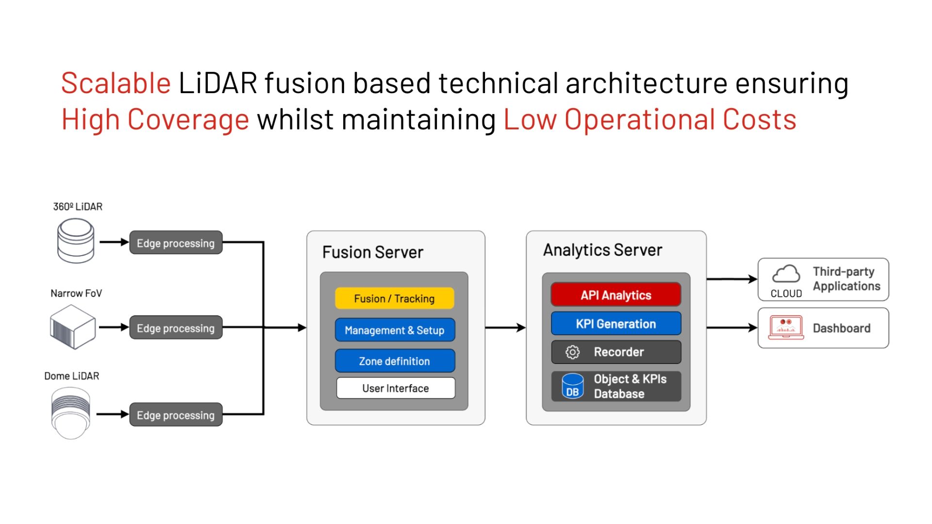
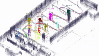
A new class of LiDAR software has been developed by businesses like Outsight that handles a heterogeneous input of data from various manufacturers and LiDAR types in real time to offer only pertinent information, in this case, monitoring humans with their position, speed, etc.
Outsight's software delivers a light-weight data stream in an open format that enables many different use cases, using the appropriate LiDAR or a combination of different kinds of them depending on the situation, in place of the complexity of many proprietary protocols and massive amounts of raw data:
Achieving Operational Excellence
Hardware is now both reasonably priced and perfectly suited for infrastructure applications like airports. Additionally, the software required to make it functional has finally been created.
What application does this technology have at places like Charles-de-Gaulle Airport in Paris?
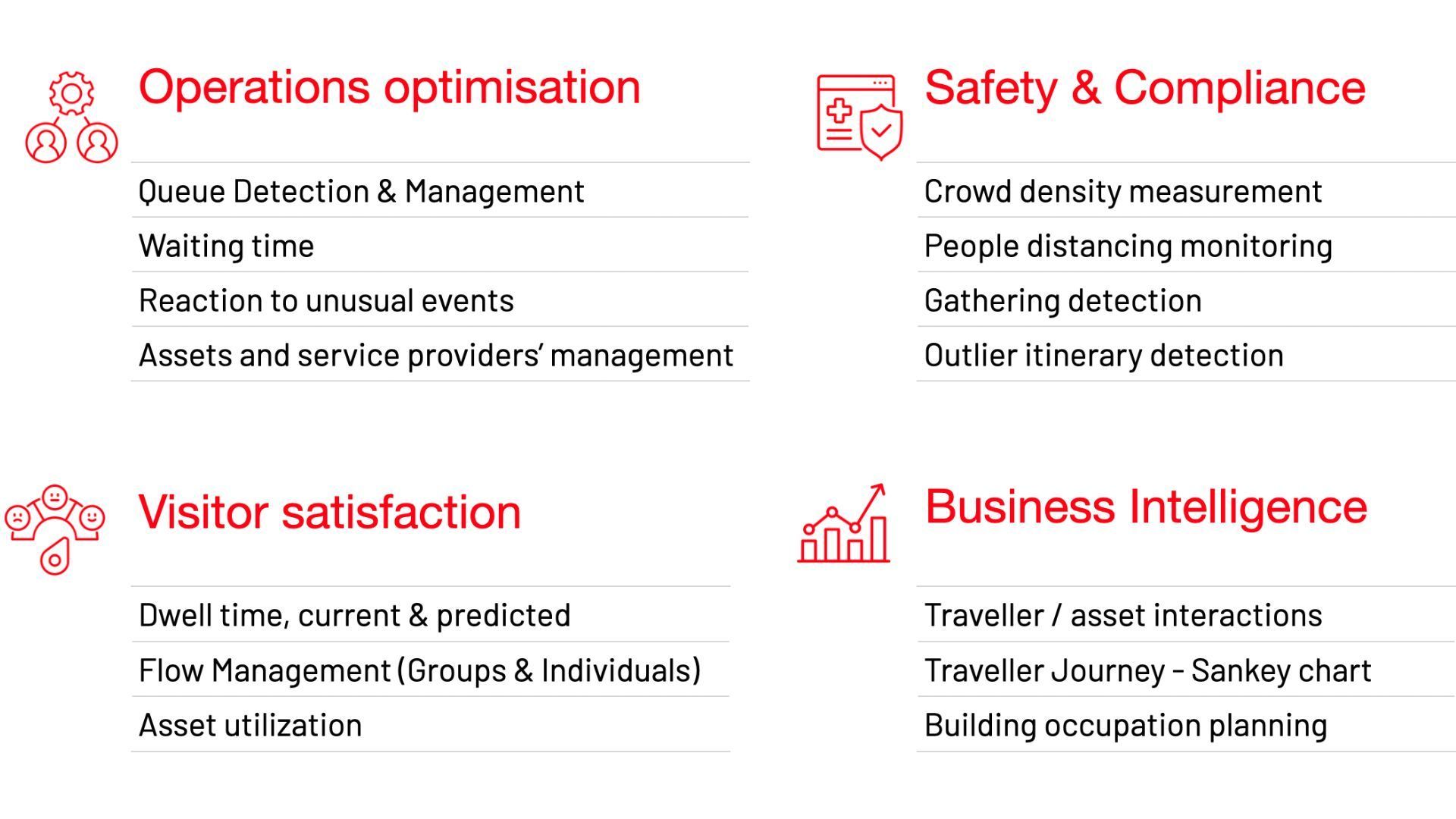
The figure below summarises some applications:
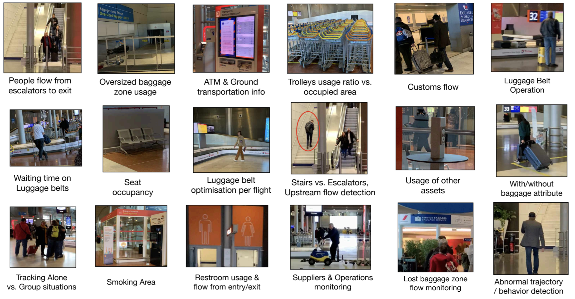
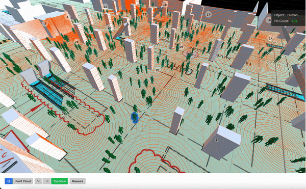
Only in a Luggage Claim zone you can find many concrete use cases:
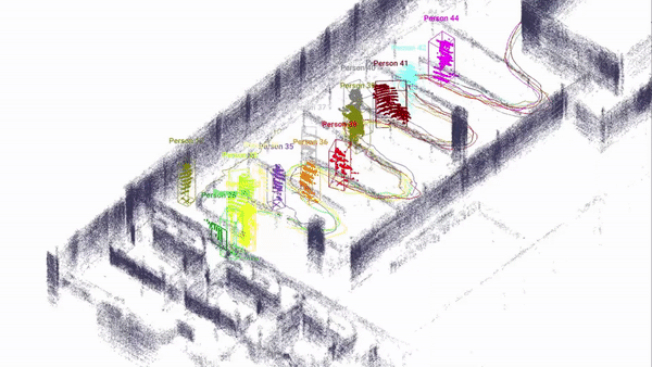
In a Passport Control zone, the precise tracking of each individual allows streamlining the process and allocating the right resources at the right time:
In order to deliver this new level of Spatial Intelligence to Airports, several requirements are mandatory for such a software Solution:
Ability to keep an eye on wide spaces
More than just a sensor and object tracking software is required to monitor a large area spread across many thousands of square meters, on several levels, from parking through departures and arrivals.
It is necessary to deploy a complete solution, such as the multi-LiDAR Fusion offered by Outsight, that enables the seamless integration of dozens to hundreds of sensors.
To achieve peak performance, it is essential to concurrently control the precise location, orientation, and timing of each individual LiDAR.
Only the greatest edge processing software can manage the load that processing millions of points per second places on the local network.
As sensor resolution rises—some manufacturers may provide sensors with a fivefold increase in resolution over the next 18 months—this will become more and more crucial.
Benefits from having that developed are substantial.
You may now pose many more important queries because of the Spatial Intelligence supplied by LiDAR-based software solutions like those provided by Outsight:
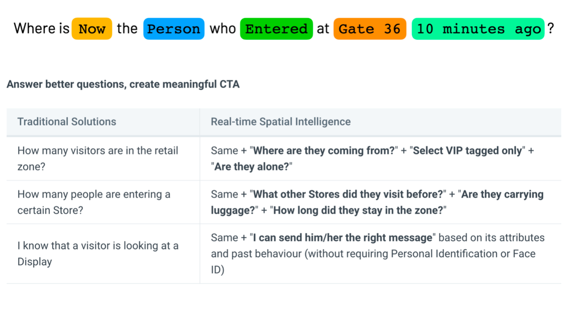
Capability of extracting aggregated and real-time KPI data
Outsight's airport LiDAR solutions go beyond simple object tracking.
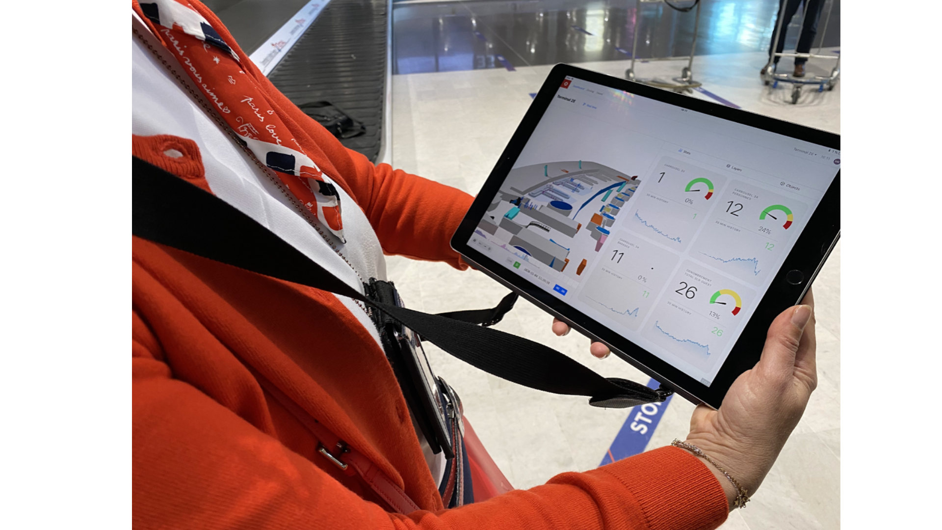
Additionally, they provide a usable Dashboard that can be accessed from any web browser and allows customers to configure the appropriate KPIs.
With the flexibility to dive into previous data to better understand occurrences and trends, the Dashboard provides both in-the-moment warnings and cumulative data over time.
This guarantees the accuracy and worth of the information.
For a sense of scale, the Outsight technology, which has been implemented in airports like Charles-de-Gaulle Airport in Paris, has already gathered 3.8 billion anonymized data points that are freely accessible to authorized operators.
Scalability and future-proofness
As we've seen, the market for LiDAR hardware is highly vibrant and diversified.
There is no one-size-fits-all solution since different sensors and manufacturers have distinct advantages, disadvantages, and price points.
The three LiDARS models that may be applied at airports are as follows:
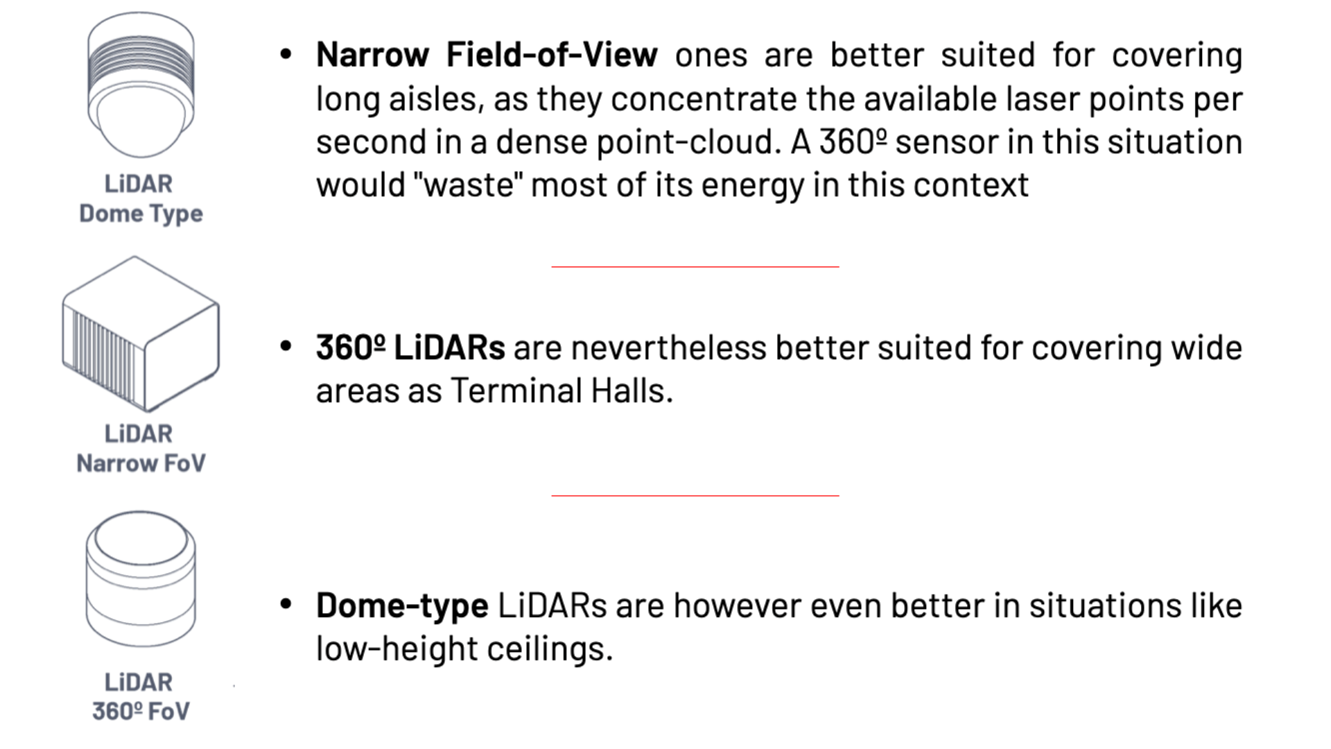
The resolution of short-range sensors, which generally operate at 905 nm wavelengths, makes them superior for confined environments.
However, long-range sensors, which generally operate at 1550 nm, are excellent for covering large areas and are particularly useful in tarmac and for perimeter protection.
The optimal sensor must be utilized for the intended purpose, according to airport operators.
For both short-term and long-term success, using, integrating, and combining numerous sensors from diverse manufacturers is crucial. One of Outsight's clients, for instance, installed a first site with a specific manufacturer at an international airport.
The second location was set up using a mix of equipment from two different vendors due to the unique physical design and restrictions. Three different hardware sensors were therefore required for the first two sites. In the future, more sites could require various ones.
Capacity to oversee a project's whole lifespan
Airports must rely on purpose-built comprehensive solutions that cover the full project lifecycle due to the difficulty of integrating 3D LiDAR to gather spatial intelligence.
3D planning and simulation are essential for determining the optimal solution for the full project lifetime. The 3D LiDAR Simulation tool, created by Outsight with this objective in mind, plays the following role:
Only open API solutions with standard protocols can ensure the needed flexibility as the project develops and the solution is progressively integrated to other airport systems.
Conclusion
When it comes to the adoption of extensive LiDAR-based solutions, airports are at the forefront of all Smart Infrastructure applications.
As a result, we now have access to the special insights that can only be gleaned from 3D data, whether for quick response (alarms) or evaluating aggregated data over extended periods of time (KPI's in Dashboard).
With the added benefit of innate respect for Privacy, this offers a degree of Spatial Intelligence that was previously unattainable by conventional 2D sensors like cameras.
Airports can now give an enhanced and user-friendly experience to travellers while also achieving a new level of operational excellence and security thanks to these new 3D LiDAR-based technologies.
LiDAR INSIGHTER Newsletter
Join the newsletter to receive the latest updates in your inbox.


