Enhancing Passenger Experience and Efficiency in Airports Through Data Insights Paid Members Public
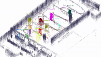
Airports can enhance passenger experiences and efficiency by leveraging real-time data insights to optimize customs, baggage handling, and transfer processes. This strategic approach not only minimizes wait times but also boosts overall Airport Service Quality, creating smoother travel experiences.

Transforming Your Airport Journey: The Role of LiDAR and Data Paid Members Public
LiDAR technology and integrated data enhance airport efficiency by improving queue measurement, enabling real-time insights, and optimizing passenger flow management.

Understanding the Essentials of Simultaneous Localization and Mapping Paid Members Public
Simultaneous Localization and Mapping (SLAM) is essential for autonomous robots, enabling them to map environments and determine their position. By integrating advanced sensors and algorithms, SLAM enhances robotic navigation and efficiency in various applications.

The Importance of Flexible LiDAR Sensor Selection Paid Members Public
Selecting the right LiDAR sensor is crucial for meeting specific operational needs and avoiding lock-in, which can hinder performance across diverse environments. Embracing flexible, sensor-agnostic solutions enhances efficiency and enables organizations to adapt seamlessly to evolving demands.

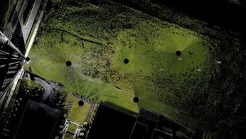
Streamlining Airport Checkpoints with LiDAR and Spatial Intelligence Paid Members Public
LiDAR technology is revolutionizing airport checkpoints by enhancing passenger flow monitoring, reducing wait times, and improving overall security and experience. This innovative approach ensures airports operate with greater efficiency and responsiveness to traveler needs.

Building Information Modeling (BIM) and Lidar: Revolutionizing Structural Lifecycle Management Paid Members Public
Discover how Building Information Modeling (BIM) and Lidar technology are transforming the management of large structures, enabling accurate and efficient documentation of changes throughout their lifecycle.

Highlights from the December 2023 Edge AI and Vision Alliance Forum Paid Members Public
Explore the latest advancements in AI and visual intelligence showcased at the December 2023 Edge AI and Vision Alliance Forum, including edge AI subsystems, microprocessors, multi-camera solutions, anomaly detection, and more.

Spicer Group Expands Remote Sensing Capabilities with 2nd Mobile LiDAR System Paid Members Public
Spicer Group Inc., a surveying and engineering company, has announced the addition of a second mobile LiDAR system to enhance their remote sensing capabilities.