
Spicer Group Expands Remote Sensing Capabilities with 2nd Mobile LiDAR System
Spicer Group Inc., a surveying and engineering company, has announced the addition of a second mobile LiDAR system to enhance their remote sensing capabilities.
Spicer Group Inc., a well-established surveying and engineering company, has recently acquired a second mobile LiDAR system. This new addition allows the company to expand its remote sensing capabilities, offering a wide range of benefits to their clients.
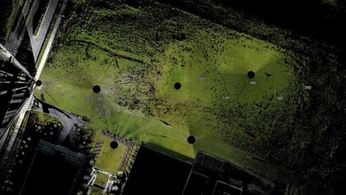
LiDAR (Light Detection and Ranging) technology uses laser pulses to measure distances and create detailed 3D maps of the terrain. It is widely used in various industries, including surveying, engineering, construction, and environmental monitoring. With the addition of a second mobile LiDAR system, Spicer Group Inc. can now collect data more efficiently, covering larger areas in less time.
The deployment of mobile LiDAR systems eliminates the need for manual measurements and decreases the time spent on fieldwork. The collected data is highly accurate and can be used to generate precise topographic maps, perform volumetric calculations, and assess the condition of infrastructure. This technology greatly enhances the speed and efficiency of surveying and mapping projects.
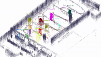
In addition to improved efficiency, the second mobile LiDAR system also offers enhanced data quality. The system utilizes advanced sensors and software algorithms, allowing for improved resolution and higher point density. This enables Spicer Group Inc. to provide clients with more detailed and accurate information, facilitating better decision-making and planning.
The expansion of Spicer Group Inc.'s remote sensing capabilities with the acquisition of the second mobile LiDAR system has significant practical applications. It allows for faster and more accurate data collection, which is essential in various industries. From infrastructure development to environmental monitoring, this technology plays a crucial role in project planning and execution.
The addition of the second mobile LiDAR system is a testament to Spicer Group Inc.'s commitment to innovation and meeting the evolving needs of their clients. By staying at the forefront of technological advancements, the company continues to provide high-quality and efficient services. This latest expansion marks an important milestone in Spicer Group Inc.'s journey of delivering cutting-edge solutions to their clients.
In conclusion, the incorporation of a second mobile LiDAR system by Spicer Group Inc. significantly enhances their remote sensing capabilities. This technology brings numerous benefits to clients, including faster data collection, improved data quality, and more accurate project planning. Spicer Group Inc.'s commitment to innovation ensures that they remain a leader in the surveying and engineering industry.
Final Thought: The adoption of mobile LiDAR systems by surveying and engineering companies represents a significant advancement in remote sensing technology. As the industry continues to evolve, we can expect further innovations that will continue to improve efficiency and accuracy in various applications.
LiDAR INSIGHTER Newsletter
Join the newsletter to receive the latest updates in your inbox.
