
Bringing Color to Lidar Scans: SimActive and LiDARUSA Collaboration
SimActive's Correlator3D™ software now allows users of LiDARUSA's multi-sensor systems to effortlessly colorize lidar point clouds, enhancing the understandability of the data.
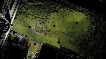
Lidar, or Light Detection and Ranging, imagery provides detailed and accurate models of ground elevation, offering vertical precision.
With its flexibility and precision, Lidar imagery proves valuable for professionals seeking a deeper understanding of various surfaces. It allows users to unveil the terrain hidden beneath tree canopies or, with Bathymetric Lidar, explore riverbeds beneath the water's surface.
Nevertheless, comprehending Lidar data can be challenging. Unlike traditional imagery, Lidar lacks color information, presenting users with elevation or intensity values to interpret.
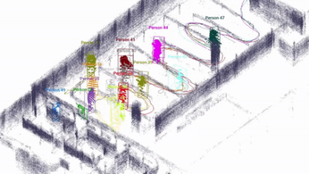
SimActive Inc. introduces an exciting development as it integrates its lidar point cloud colorization capabilities with the multi-sensor systems created by LiDARUSA.

This collaboration enables users to harness the power of SimActive's Correlator3D™ software, which seamlessly combines imagery and lidar data, making lidar information more accessible and comprehensible.
The process begins by importing lidar point clouds into Correlator3D™, where the collected imagery is automatically aligned with the lidar data using it as a reference for registration. Subsequently, each lidar point is enriched with colors extracted from the corresponding images, enhancing the overall visual representation.
“While lidar is great, everyone understands imagery. Colorizing lidar makes the data much more understandable”, “Correlator3D allows our clients to easily colorize lidar point clouds from their multi-camera system.”
- said Jeff Fagerman, CEO at LiDARUSA
Correlator3D™ software, developed by SimActive, stands as a pioneering and patented end-to-end photogrammetry solution.
SimActive's software offers a comprehensive solution for producing high-quality and accurate geospatial information.
LiDAR INSIGHTER Newsletter
Join the newsletter to receive the latest updates in your inbox.
