
Geospatial Case Studies: Empowering Innovation through Real-World Applications
Explore how geospatial information has transformed towns, cities, and states in Mexico, and learn about the hands-on use of technologies and methodologies in the geospatial realm, empowering professionals to overcome obstacles and inspire innovation.
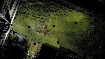
Geospatial information has made a significant impact on the transformation of towns, cities, and even entire regions in Mexico over the past 15 years. Through collaboration between customers and data providers, up-to-date datasets have been created to enhance decision-making processes. Such case studies shed light on the practical use of geospatial technologies and methodologies, empowering professionals to address challenges efficiently and drive innovation.
Advancements in technology have revolutionized surveying techniques and solutions, offering a myriad of options for users. However, the abundance of devices and technologies available in the market can be overwhelming for buyers. This article highlights the rapid advancements and improvements in technology, providing insights to help navigate the densely populated market.
The integration of geospatial information software (GIS), remote sensing, and surveying and mapping data has accelerated in recent years. The use of AI models and ChatGPT has introduced new possibilities in data analysis and interpretation. This article explores the integration of these technologies and the impact they have on the geospatial industry.
Aerial cameras play a crucial role in capturing accurate and up-to-date imagery for various applications. The article introduces the WARP Omni convertible camera, designed to be competitive with satellite and UAV imagery solutions. This camera offers productivity, versatility, and cost-effectiveness for professionals in need of high-quality aerial imagery.
The podcast series "Scanning Realities" by NavVis delves into the past, present, and future of reality capture and documentation. Experts share their insights and revelations in this episode, providing valuable information on the emerging trends and developments in reality capture technologies.
While Lidar has become a common tool in aerial mapping applications over the past two decades, it is not without its challenges. This article explores the limitations and obstacles that Lidar technology faces and offers insights into overcoming them.
Ordnance Survey, the national mapping agency for Great Britain, sought a faster and more cost-effective method for collecting georeferenced point cloud data. The article discusses their need for sustainable and efficient solutions, highlighting the importance of innovative technologies in geospatial data collection.
The EvoLogics Multibeam, a new multibeam echosounder option for the Sonobot 5 platform, was released at Ocean Business in Southampton, UK. This hardware innovation offers enhanced underwater surveying capabilities and demonstrates the continuous advancements in geospatial hardware technologies.
Unmanned aerial vehicles (UAVs) have become an essential tool for remote sensing surveys in Antarctica. These drones provide valuable data for various scientific studies, especially for mapping free-from-ice-and-snow terrains. The article discusses the increasing importance of UAVs in Antarctic research and explores their applications in data collection.
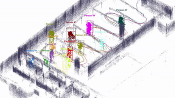
Investing in a mobile mapper can transform the day-to-day work of professionals in the geospatial industry. This article highlights the benefits and practical applications of mobile mappers and explains why it is a timely investment for individuals and organizations alike.
In conclusion, geospatial case studies offer insights into the practical use of technology and methodologies, empowering professionals to tackle challenges and drive innovation. From transforming cities to advancing surveying techniques, the geospatial realm continues to push boundaries and reshape industries.
LiDAR INSIGHTER Newsletter
Join the newsletter to receive the latest updates in your inbox.
