U.S. Forest Service Offers Online Lidar Technology Training Tutorials Paid Members Public
The U.S. Forest Service Remote Sensing Applications Center is providing six online tutorials on Lidar technology, offering valuable training opportunities.

Filtsy AR Plugin: Create a Holiday Atmosphere Anywhere with Stunning Effects Paid Members Public
The Filtsy AR Plugin allows users to instantly create a holiday atmosphere and share it with friends on Instagram and TikTok. With advanced AR technology, users can capture stunning videos with realistic water effects and other amazing features.

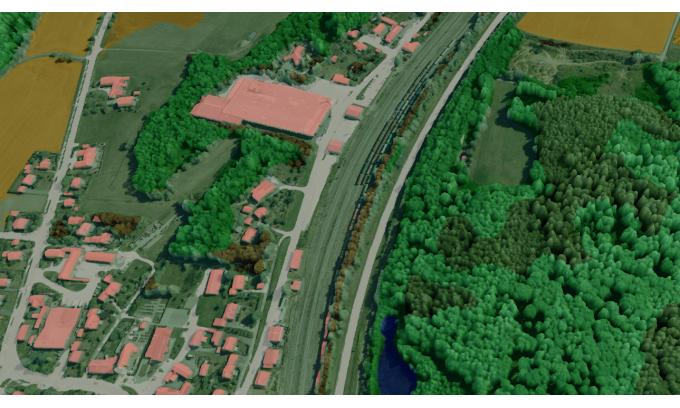
Visualizing LiDAR Data in 3D Made Easy with One Line of Code Paid Members Public
Learn how to easily visualize LiDAR data in 3D using just one line of code. This article provides step-by-step instructions and highlights different visualization methods for LiDAR data analysis.

DataSight Introduces Breakline Builder for Automated Breakline Extraction Paid Members Public
DataSight has launched Breakline Builder, a cloud-based mapping solution that analyzes point clouds and creates breaklines for building terrain models. This innovative software improves the utilization of LiDAR data.

Geospatial Case Studies: Empowering Innovation through Real-World Applications Paid Members Public
Explore how geospatial information has transformed towns, cities, and states in Mexico, and learn about the hands-on use of technologies and methodologies in the geospatial realm, empowering professionals to overcome obstacles and inspire innovation.

The Significance of Sensor Diversity in Self-Driving Cars Paid Members Public
Discover why sensor diversity is crucial for the development of self-driving cars and how it impacts the future of autonomous vehicles.

Next-2Digits Project Focuses on Advancements in Graphene-Based Sensors and Imagery Paid Members Public
The Next-2Digits project, in collaboration with GrapheneEU, aims to develop the next generation of sensors and imaging technology using graphene. This consortium of 11 European companies is committed to advancing expertise in graphene and disseminating knowledge to various stakeholders.

Fusing Aerial and Mobile LiDAR Data for Efficient Mapping Projects Paid Members Public
Discover how Caltech Group revolutionizes large-scale mapping projects by combining aerial and mobile LiDAR data.


